GA 2938 – Mulline For Discount
- Estimated Delivery : Up to 4 business days
- Free Shipping & Returns : On all orders over $200
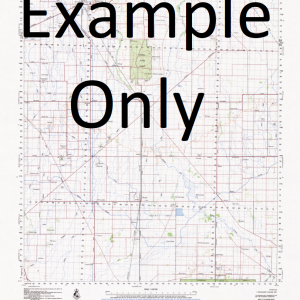
This Topographic Map is produced by Geoscience Australia; Australia s national geospatial organisation.
GA topographic maps (many of which are produced in partnership with the Army) are generally older than those maps produced by the State Governments over the same area. This makes GA maps particularly useful for identifying historic features, such as old mines and diggings.
Geoscience Australia maps generally considered to be more pleasing in design and compilation then the more modern State Government productions.
At this scale, 1cm on this map represents 1km on the ground. A standard map (which is square) covers an area of approximately 54km by 54km, with a contour interval of 20m. This map contains natural and constructed features including road and rail infrastructure, vegetation, hydrography, contours, localities and some administrative boundaries.
Please note the date of the map, as this will impact the currency of information, particularly regarding infrastructure, roads, etc.
Bullock Hole Carbine Bluff Chingaling Rock Cooladdie Rock Cooladdie Well Corktree Bore Crow Rock Gabbling Rock Galah Rocks Gedagie Soak Government Well Halag Rock Hospital Rocks Kurrajong Gorge Lane Well Lemon Rock Maninga Soak Mount Hope Mulline Rock No. 5 Bore No. 6 Bore Old Well Playground Bore Rundle Rock Scorpion Rock Sowerline Bore Sowerline Well Sowine Soak Tom Rock Yowie Rock
| Title | Paper, Laminated |
|---|
Related products
-
GA 5037-2 – Billy Online now
$12.50