GA 2843 – Montagu Discount
- Estimated Delivery : Up to 4 business days
- Free Shipping & Returns : On all orders over $200
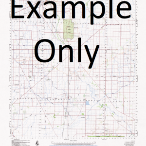
This Topographic Map is produced by Geoscience Australia; Australia s national geospatial organisation.
GA topographic maps (many of which are produced in partnership with the Army) are generally older than those maps produced by the State Governments over the same area. This makes GA maps particularly useful for identifying historic features, such as old mines and diggings.
Geoscience Australia maps generally considered to be more pleasing in design and compilation then the more modern State Government productions.
At this scale, 1cm on this map represents 1km on the ground. A standard map (which is square) covers an area of approximately 54km by 54km, with a contour interval of 20m. This map contains natural and constructed features including road and rail infrastructure, vegetation, hydrography, contours, localities and some administrative boundaries.
Please note the date of the map, as this will impact the currency of information, particularly regarding infrastructure, roads, etc.
12 Mile Bore 2 Mile Well 3 Mile Well Albany Well Barcoo Bore Bluff Point Bottle Well Bore Bungarra Rockhole Christies Bore Christies Well Cork Creek Crabhole Bore Easter Mile Bore Ed Bore Gallalee Bore Independence Bore Mallee Hen Bore Mica Well Midnight Bore Montagu Montagu Boulder Mine Montagu Mine Montagu Range Montagu Well Mount Marion Munroes Well Neds Waterhole North Well Old Government Well Paddy Bore Red Handed Bore South West Bore Surprise Bore Tadpole Bore Tonis Bore Twin Dams Bore Victory Well Wirraway Bore Montague Range Montague Well Gidgee
| Title | Paper, Laminated |
|---|
Related products
-
GA 3862-4 – Blina Sale
$12.50 -
GA 5366-3 – Birrimba Sale
$12.50